
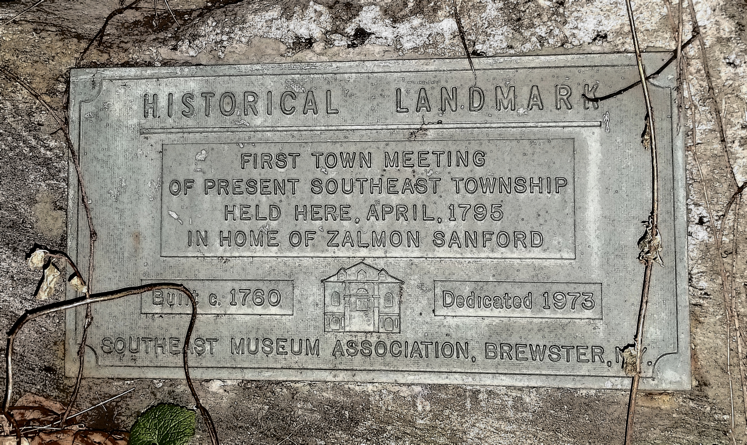
The “Triangle House” sits on an island of land in the middle of the three way intersection of Brewster Hill Rd and Tonetta Lake Rd in the town of Southeast, NY. Outside the house is a plaque designating it as the site of the first town meeting in 1795. The conventional wisdom is that this was once the home of local ancestor Zalmon Sanford.
I believe the plaque, and the conventional wisdom, is wrong.
I do believe that the first town meeting was at Zalmon Sanford’s house. I just don’t think we have the right house or location. My research is a work in progress, but below is a summary of why I think I think what I do, and where I think his house (and the first meeting site) actually was located…
Stumbling Upon a Mystery
While at the county historian’s office one day, doing research on Dingle Ridge Rd (the old stage road to Vermont) I came across a map that was supposedly done around 1795. It was created by none other than one Zalmon Sanford. It was a great map – hand-drawn, its looks like a quick sketch someone did that just happened to survive the last 220+ years. It showed some pride for the town, but it also showed a sense of humor. I have copied the inscription, complete with funky grammar, below:
“Southeast – therein are contained one meeting house, one settled minister. Eight school-houses and eight school masters. And much to our happiness not one lawyer can live among us. We have five grist mills, three saw mills. Seven licensed taverns and three physicians. One mine of iron OAR which supplys several iron works of the neighboring towns.”
See, lawyer jokes were funny even back then! (Sorry to all my lawyer friends.)
Another thing I noticed…while staring at the map and trying to orient myself so I could figure out which way was up, one feature on the map threw me off. On his map, Zalmon placed a structure, labeled the “Sanford House” south of the Croton River. At first I thought I had the map upside down. But I didn’t. So why, I wondered, would he put his house south of the river, when the Triangle House is north of the river?
Now, it’s possible he was referring to another Sanford, but it seems mighty strange that the author of the map would place another Sanford House on his map, but not his own house. Or maybe the house got moved? Possible. I have found no evidence yet that this happened. And if moving a house, it seems strange and statistically improbable to move it from one “triangle” to another. Why not take the opportunity to set it on the side of the road?
Below is the 1795 Zalmon Sanford map. The “Sanford House” is marked with a yellow dot. The spot where the road crosses the Croton River is marked with a green dot.

Checking Other Sources
I checked Pelletreau’s book on the history of Putnam County, written in 1886. On page 462, in the “Methodist Episcopal Church, Brewster” section he writes (emphasis is mine):
“1791…About this time came from Connecticut two brothers, Hezekiah and Zalmon Sanford, both of whom were zealous Methodists and godly men. The former was a local preacher and immediately began to preach in school houses and private dwellings. The house of Zalmon Sanford, which is still standing, surrounded on three sides by roads, is a short distance southwest of Southeast Center, and was a frequent place of meeting. It was also at this house that the first town meeting was held, in the town of Southeast, in 1795.”
Pelletreau puts the house on a land-island within a three-way intersection, BUT, he also places Zalmon’s house south of Southeast Center.
Next, I checked some of the old maps of the area. The 1867 Beers map shows a “Sanford Corners” at the triangle south and west of the downtown area of Southeast Center (the vicinity of the current-day Subaru and Ford dealers). The triangle contains two structures. The 1876 Reed Map also shows a “Sanford Corners” in the same area.
Wait, what is Southeast Center?
Let me pause here and define “Southeast Center”. Back in 1795, Southeast Center was the most populated section of town, the “downtown” area where there was a cluster of buildings and people. Before the village of Brewster started in 1848, Southeast Center was the center of activity. It was the area that is current-day Sodom Road, centered approximately at the current-day intersection of Brewster Hill Rd and Sodom Rd, where the Croton River crosses under the road.
The Triangle House, on the other hand, sits a mile north of the epicenter of the old Souteast Center (or Southeast Centre as it says on the old maps). Why would people in the late 1790s travel that far for a town meeting? Common sense tells me that they would choose a more central location.
Back to Researching
Another source, the Historical and Genealogical record, Dutchess and Putnam counties, New York, published in 1912 notes, “The house of Zalmon Sandford, which is still standing, surrounded on three sides by roads, is a short distance southwest of Southeast Center [originally Sodom], and was a frequent place of meeting.” While this basically sounds like a cut-and-paste of Pelletreau’s description, this also supports my theory – and they indicate the structure was still there.
Since Zalmon and his brother Hezekiah were Methodists, I contacted the archivist of the New York Annual Conference of the United Methodist Church, based in White Plains. Among other items, the archivist there sent me a transcript of a lecture by Harold B. Truran that was given in 1934 to celebrate the 100 year anniversary of the old Methodist Church in town. In his article, after paraphrasing Pelletreau’s above quote, he adds,
“Probably several here tonight will recall that old farmhouse at the present intersection of Route 6 and 22, in which Zalmon Sanford lived and in which the first town meeting of the Town of Southeast was held.”
This was super helpful, because it comes from someone that remembers a particular structure associated with Zalmon Sanford. He also places Zalmon’s house south of the Croton River. He goes further to give an “address” of sorts – the intersection of 22 and 6 – but over time roads get re-routed to better serve the users of the time, so its not safe to assume that the layout of current Route 6 and 22 is the same as it was in 1934. Heck, I-84 and I-684 definitely did not exist in 1934. Fortunately, 1934 isn’t that long ago, and I figured there’s was a good chance I could determine the layout of those roads at that time, and compare that to today’s layout.
Lucky for me, the Putnam County Historian’s office has a series of aerial photos from 1938. What I learned from studying the old maps and aerial photos was this: The roads did indeed change…a lot! Before Route 84 and 684 came through, what is now Route 22 was the main north/south road through this area. It was a winding, curving road. Back in the 1930s there was a project to straighten the road to improve transport – which is why we have all those side roads called Old Rt 22. The “new” wider and straighter Route 22 came up from Somers, but instead of curving right at the current-day Valero station, it continued straight, following what is now Sodom Road. This stretch of road, from the current-day Valero gas station to the the Henry Van Motel, was high traffic, which explains why the Henry Van Motel is where it is. (Right across the street from the motel there is a current-day kitchen cabinet place, which used to be a Harley Davidson dealer.) If you stop at the stop sign next to the kitchen cabinet place, you will notice that the two other roads that meet at that intersection are dead-ends. They weren’t always that way. One old road used to continue straight and lead up to the area of Route 22 where Lakeview Plaza is now. The other dead-end was a road that met up with the intersection where the Ford Dealer and the old Crossroads Cafe are.
I found another passage in the book Brewster Through the Years 1848-1948 on page 3 says, “The home of Zalmon Sanford became the first Towne House, and was used for early religious services and social activities. Zalmon Sanford’s house still stands in the triangle at the foot of Brewster Hill. The first town meeting was held there in 1795.” This source seems to support the idea that the Triangle House was indeed Zalmon Sanford’s. However, this book was written after 1944 – and as I will show next, in 1944 there was a lecture that laid claim to the house being at the Brewster Hill/Tonetta Lake triangle. i believe this book relied on information from this 1944 lecture, but the 1944 lecture was either a correction of earlier historian knowledge, or an error that stuck and has been repeated util today.
I have found nothing prior to 1944 that places Zalmon Sanford’s house north of the Croton River. All earlier sources place the house south of the Croton River. However, in that year Laura Voris Bailey presented a lecture titled, “A Historical Sketch of Brewster, New York” that she read at the regular meeting of the Enoch Crosby Chapter of the Daughters of the American Revolution on March 13th. In that lecture she described (emphasis is mine):
“The following is a paragraph taken from an Act of Legislature March 17, 1795: “Be enacted by the People of the State of New York, represented in Senate and Assembly: That all those parts of Frederickstown and Southeast Precinct lying east of said line (referring to the line defining the Town of Carmel) of Phillipse’s Long Lot, lying six miles from the north bounds of Westchester County, and running 87 degrees, 30 minutes east, and continued to the State of Connecticut, shall be erected into a separate Town by the name of Southeast, and the first Town Meeting of said Town of Southeast, shall be held at the dwelling house of Zalmon Sanford in the town of Southeast”,
Another paragraph in the act provided that “the first regular Town Meeting of said Town of Southeast shall be held the first Tuesday in April 1796”. Thus the Town of Southeast came into independent existence, however, the town continued as part of Dutchess County until Putnam was separated from Dutchess and was erected as an independent County by Act of Legislature on June 13, 1812.
The home of Zalmon Sanford stood at the meeting of three roads at the foot of Brewster Hill. As this house was located in approximately the center of the township, the name of the meeting place became Southeast Center.
Roads were rough, but they all lead to or from Zalmon Sanford’s house. These roads were broken out as links between the isolated homes of the settlers, and generally were very tortuous. Very little road-mileage as is now known as Routes 6 and 22 was in existence. There was a road connecting Peekskill and Danbury, another leading from White Plains through Somers to Pawling, but not following for many miles the present highways. General Washington traveled over many weary miles of these old roads during his campaign in the Revolution. Owing to various reasons, such as abandonment or original home sites, condemnation and confiscation of lands for railroad right-of-way, and flooding of much acreage for storage reservoirs for water supply for New York City, most of these old roads have disappeared. However, there is one stretch of road leading from the Township of Patterson, over Brewster Hill, through Southeast Center, out through Sodom, along the Croton River, following All View Avenue, over Turk Hill Road to the home of Samuel Field, which has preserved its original route.
So, my first doubt is that she describes the location of the current-day Triangle House as Southeast Center. While she is correct to say the Triangle House sits in the approximate center of the (new in 1795) borders of the town of Southeast, the older maps clearly indicate that Southeast Center was a full mile south of the Triangle House.
My second doubt is her description that all roads let past the Triangle House. When I read her passage about all roads leading to or from Zalmon Sanford’s house, it reminded me of something I had read in Pelletreau’s book that, for whatever reason, had stuck with me since I first read it. Her description was reminiscent of how Pelletreau describes Southeast’s early roads of Southeast on page 414 of his 1886 book (emphasis is mine):
“The next definite knowledge of the early settlers is in the record of the laying out of roads in 1745, which is found in the clerk’s office of Dutchess county. From this record some idea may be gained as to the location of early settlers in the town. James Dickinson, from whose place several roads radiated, probably lived on the south side of Croton River, at Southeast Center, and on the farm afterward owned by Hezekiah Sandford, whose house is still standing at the intersection of three roads, leading respectively to Brewster, Milltown and to Westchester county; the latter being called the ” Peach Pond road.””
Pelletreau makes the Dickinson place sound like the epicenter of where the major roads meet, while the 1944 lecture says it is the Triangle House. To me, it sounds like Pelletreau is talking about the area that is between the current Subaru and Ford dealers, and the current intersection of Brewster Hill Road/Sodom Road. From that location, both current and various past maps show roads leading to Brewster, Milltown and Peach Pond.
Ms. Bailey puts this important early junction a mile north of what was the “busy” section of town back then. Assuming that Ms. Bailey in her passage is attempting to describe the same junction that Mr. Pelletreau is in his passage (they may not be, which would be my misunderstanding), Pelletreau’s version seems more plausible. He was describing the location of “downtown” Southeast Center. The 1944 lecture is describing a junction a full mile north of the developing business center of town – at best a decent horseback rider and at worst a long walk. I have run Brewster Hill, from the Subaru Dealer to the High School, and I can tell you that is one heck of a hill without the assistance of a combustion engine or horse-hoofs. But most striking between the two descriptions is that, I think importantly, there is no road from the Triangle House that leads to Milltown.
There is plenty of evidence that the Triangle House is indeed an old house. I have researched the deeds back to the 1850s, but I have yet to find Zalmon’s name anywhere. Perhaps I am just wrong, and in 1795 everyone happily accepted the one mile walk or horse ride to the Triangle House. Problem is, I can’t find any other sources or evidence other than the 1944 Bailey lecture and the 1948 Brewster Through the Years book, to verify the statement that the Triangle House and Zalmon Sanford’s house are one and the same.
Who Was Zalmon Sanford?
Zalmon Sanford came to Southeast from Redding, CT. His parents were Hannah and Hezekiah Sanford. He was baptized September 13, 1767, and married Rachel Reynold. While unconfirmed, an online search indicates Rachel died March 21st, 1809, and Zalmon died a month later on April 30th, 1809. He is buried in Milltown Cemetery, near the middle entrance, relatively close to the road (see photo at end of article).
I was able to find a copy of his Last Will and Testament. Aside from the notable fact that he seemed to leave his wife (which is messy if she pre-deceased him) the use of a slave named Charles until he turned 21, he also mentions in his will that a road ran north/south through his property (clue #1), that there was a schoolhouse on his property(clue #2), and that he offered land and money to the local Methodist Society to build a church(clue #3). This is interesting to me, because the first Methodist Church in town that I know of was at the intersection of current day Rt 22 and Allview Ave. There was also a school there at some point, too. This further supports my theory that the Triangle House was not Zalmon’s home.
Conclusion
After all this research, I believe the Zalmon Sanford House was located somewhere near the current-day Ford and Subaru dealers, or perhaps where the old Crossroads Cafe was located (which is a whole different article, because I have to wonder if Crossroads got its name from being the location that Pelletreau describes as where three major roads met in 1745). The old maps and aerial photos support my theory on where Zalmon’s house was. I believe the Zalmon Sanford house was torn down, burned down, was moved, or was somehow other disposed of, most likely when Route 84 was built. I believe the Triangle House is old, but was not Zalmon’s house and was not the site of the first town meeting. I don’t know if I will ever find the proof I need, but I’ll keep trying.

Above: Close-up of the 1876 Reed Map. The top circle is the site of the Triangle House. The center circle shows the buildings and area of “downtown” Southeast Center. The bottom oval shows the triangle labeled as “Sanford Corners” which is where I think the first town meeting was held. Map courtesy of the Putnam County Historian’s office.

Above: Close-up of 1867 Beers Map. Top-most circle is the Triangle House. Middle oval is Southeast Center. Lowermost oval is Sanford Corners. Map courtesy of the Putnam County Historian’s office.

Above: 1938 aerial photo of area of Southeast Center and Sanford Corners. The Triangle House location if off the top of the map. Circled area is what I believe is the Zalmon Sanford House. The location of the current day Subaru Dealer, cabinet store and Mobil station are marked for reference. Photo courtesy of the Putnam County Historian’s office.

Above: A portion of Zalmon Sanford’s last will and testament.

Above: Zalmon Sanford’s headstone in Milltown Cemetery.